
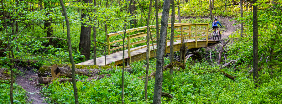
The green trail passes through a deep ravine with large Glulam bridge.
Want to get Involved?
There will be plenty of opportunities for volunteer help on this project and the more help we get the faster the new trails will be ready for use. Click here to view the latest trail work day announcements. Click here to subscribe to the Dorrance forum (forum account required) to receive email updates about upcoming work days and the latest project developments.Summary
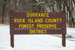
Dorrance Forest Preserve is located right in the middle of Port Byron, IL making it a prime choice for recreation and specifically trails. This 80 acre park features moderate to steep terrain and is covered by large hardwood trees typical of the Mississippi River valley. The park is located just a short ride from downtown Port Byron making it a convenient recreation destination for locals or those just visiting.
Trail Map
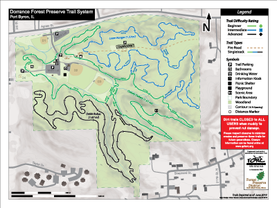
Click to enlarge
Planned Trails
Three main loops of trail will be constructed at Dorrance. A green beginner loop, blue intermediate loop, and black advanced skills loop. Each trail will be around 1 mile in length with approx. 4 miles of trail in total when finished.
Trail Descriptions
- Green Loop - "Oakely Dokely" (Beginner
 ) A 1.6 mile loop tracing the interior of the park. A wider trail surface and low gradients makes this a good fit for beginner riders. The loop features a couple moderate climbs and one long descent. Enter/exit near the kiosk along the entrance road.
 - Blue Loop - "Loam Ranger" (Intermediate
 ) A 1.5 mile loop with numerous rollers, rock features, optional drops, and a few short climbs. One way only trail! (CW)
- Black Loop - "Unkle Rukus" (Advanced
 ) This trail features, drops, steeps, steps, log overs, ladder bridges, and other advanced features to challenge riders (some without ride-arounds). Features will be added on Phase II during the winter/spring 2018/2019. One way only trail!
Trail Information
FORC is working with RICFPD to develop new trails at Dorrance. The green/beginner loop was completed in spring 2017 and the intermediate skill level blue loop in Fall 2017. There is one more trail being constructed in 2018. Total singletrack trail mileage when completed is expected to be around 4 miles. Trail format is a stacked loop system, like many other local trails, with a main loop that is wider and less technical and two more technical/difficult loops branching off. Permitted trail uses include mountain biking and other human powered activities.
There is also a short out-and-back hiking trail/road along the northernmost ridge paralleling Agnes Street.
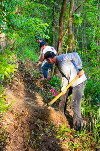
FORC volunteers building trail at Dorrance.
Park Hours
- Trails open daily 1/2 hour before sunrise and close at 10:00 pm. Be off the trails and ready to leave before 10pm.
- Gates blocking access to the interior parking lot are closed during the winter months (December to April).
Trail Closures
Trails at Dorrance are closed to all users when wet and muddy to prevent rut damage. Trail closures are controlled by Dorrance park staff but are relayed to us and will be displayed on the trail status in the upper left hand corner of this page. Trails are typically closed for 24 hours or more after 0.20" or greater rainfall and during freeze thaw cycles as necessary in winter months.
Directions
Just North of Port Byron, IL on IL-84 or 3.5 miles North of I-80 on IL-84 (take the first/last exit entering/exiting Illinois and turn right on IL-84).
Parking can be limited during summer evenings when ball games are in effect, which is most weeknights. An overflow parking lot is available at the top of the gravel road to the north of the interior diamonds (see trail map). Please don't block trail crossings along the roads!
More Info
Dorrance Forest Preserve is managed by the Rock Island County Forest Preserve District. On site features include bathrooms, softball/baseball diamonds, soccer fields, playground, small picnic shelter, and close proximity to the Great River Trail.
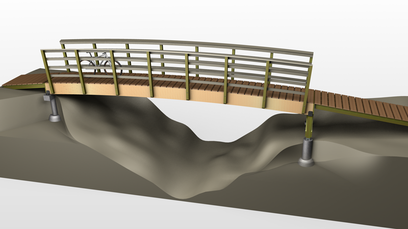
This 33' bridge will be constructed over winter 2016 to complete the 101 loop.
Project Updates - [Progress Photos Here]
- November 2018 - Opened second phase of black loop.
- September 2018 - Opened first phase of black loop (~40% complete).
- May 2018 - Clearing begins on the black loop.
- February 2018 - Black loop route flagging completed.
- December 19th 2017 - Loam Ranger (blue loop) trail finished.
- November 2017 - Signage installed.
- October 2017 - Second section of blue loop completed.
- August 2017 - First section of blue loop completed.
- June 2017 - Construction of first section of blue loop begins.
- May 2017 - Grand opening of the green loop.
- April 2017 - Completion of the Glulam bridge project.
- December 2016 - Layout of the blue trail.
- November 2016 - The green trail is completed with the exception of a 33' bridge crossing a deeply incised stream.
- April 2016 - Construction of green trail begins.
- March 2016 - Layout of green trail.
In The News
Below is a collection of local news articles about the development of the Dorrance trails.
- QC Times - Mountain Bikers Construct Multi-use Trail, Bridge in Port Byron
- QC Online - Hiking/Biking Trails Being Added to Dorrance Park
- QC Online - Off-road Cyclists Boost Dorrance Park Trails
Project Partners
Big thanks to our partners who have provided resources and funding to make this project a reality!
