• Credit Island and Mississippi River Shorline

    An example of the natural features to play on.
    The shoreline and river bottoms along and near Credit Island Park in Davenport is a fat biking paradise. No trail system exists, so it is bushwhacking, adventure and exploration at its finest. The summertime shoreline along Credit Island provides a rocky and sandy area to test your fat skills. Wintertime is the best time to ride, when local trail systems (Illiniwek, Sunderbruch, etc) may be closed or unrideable due to deep snow or the freeze/thaw cycle. This Credit Island area is in the Mississippi flood zone, therefore no trails are built or maintained. Upriver or downriver, ride the shoreline as well as the inland wooded areas, finding technical challenges such as downed tree trunks, logs, boulders and root systems upon which you can spend hours refining your skills. Be sure to take a moment to enjoy the views and observe the Bald Eagles that winter in the area.

    Research the water levels [Davenport Gauge | Muscatine Gauge] in advance for a better riding experience, and as always use good judgment, be safe and ride responsibly. The area is always open except during periods of significant Mississippi River flooding when the City of Davenport closes Credit Island park and adjoining bike paths and roadways.

    In late 2014, FORC adopted two Iowa side river miles via the “Adopt-A-River Mile” program initiated by Chad Pregracke and his Living Lands & Waters foundation. The miles are based upon US Army Corps of Engineers river navigation charts; FORC adopted miles 479 & 480. Mile 479 starts about ¼ mile from the lower tip of Credit Island, and goes upriver. The upper end of Mile 480 ends on the shoreline directly across from Midwest Metals on River Drive/US Hwy 61 (roughly ½ mile upriver from the Credit Island Park entrance road).
    Great views of downtown Davenport.

    FORC organizes an annual cleanup of trash along the shoreline. Keep an eye out for announcements if you want to help during the cleanup.


    DIRECTIONS


    Credit Island Parking

    Park near the boat ramp or lodge; there are yellow gates that get locked from dusk till dawn to prevent parking on remote downriver areas of Credit Island.

    From I-280, exit at West River Drive, head East into Davenport about 3 ½ miles and turn right (South) on the Credit Island Park entrance road.

    From downtown Davenport, head West on River Drive (aka South on US61). Drive about 2 miles and turn left (South) on the Credit Island Park entrance road.
    Credit Island bike path bridge leads to more adventure on the Iowa shoreline.

    Downtown Parking

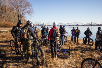
    Free parking is available near Modern Woodman ballpark and the Freighthouse Market. Get on Davenport’s Riverfront bike path and head downstream, riding past the Marquette Street boat ramp. Drop onto the shoreline anywhere downstream from the Train Bridge crossing the river (this is not the Govt/Arsenal bridge). NOTE that the first ¼ mile section is not adopted by FORC and it seems many transients litter the place in summertime, so beware of broken glass in this area.
  • Local Trail Conditions

    Report Trail Issue

    Sylvan Island

    Open

    Sunderbruch

    Open

    Scott County Park

    Open

    Illiniwek

    Open

    Westbrook

    Caution

    Stephens

    Closed

    Prairie Park

    Closed

    Dorrance

    Open Some Soft Spots

    Dog Park

    Open

    Scott Community College

    Closed

  • MTB Trail Etiquette

    • Ride Open Trails: Respect trail and road closures — ask a land manager for clarification if you are uncertain about the status of a trail. Do not trespass on private land. Obtain permits or other authorization as required. Be aware that bicycles are not permitted in areas protected as state or federal Wilderness.

    • Leave No Trace: Be sensitive to the dirt beneath you. Wet and muddy trails are more vulnerable to damage than dry ones. When the trail is soft, consider other riding options. This also means staying on existing trails and not creating new ones. Don't cut switchbacks. Be sure to pack out at least as much as you pack in.

    • Control Your Bicycle: Inattention for even a moment could put yourself and others at risk. Obey all bicycle speed regulations and recommendations, and ride within your limits.

    • Yield Appropriately: Do your utmost to let your fellow trail users know you're coming — a friendly greeting or bell ring are good methods. Try to anticipate other trail users as you ride around corners. Bicyclists should yield to other non-motorized trail users, unless the trail is clearly signed for bike-only travel. Bicyclists traveling downhill should yield to ones headed uphill, unless the trail is clearly signed for one-way or downhill-only traffic. In general, strive to make each pass a safe and courteous one.

    • Never Scare Animals: Animals are easily startled by an unannounced approach, a sudden movement or a loud noise. Give animals enough room and time to adjust to you. When passing horses, use special care and follow directions from the horseback riders (ask if uncertain). Running cattle and disturbing wildlife are serious offenses.

    • Plan Ahead: Know your equipment, your ability and the area in which you are riding and prepare accordingly. Strive to be self-sufficient: keep your equipment in good repair and carry necessary supplies for changes in weather or other conditions. Always wear a helmet and appropriate safety gear.