
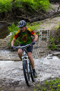
Dog Park Trails are under new management! FORC and Dog Park have parted ways. These trails are now being maintained by residents of the Kimberly Village neighborhood. For questions and to report trail issues please reach out via their Facebook Page here: Dog Park Trails Group
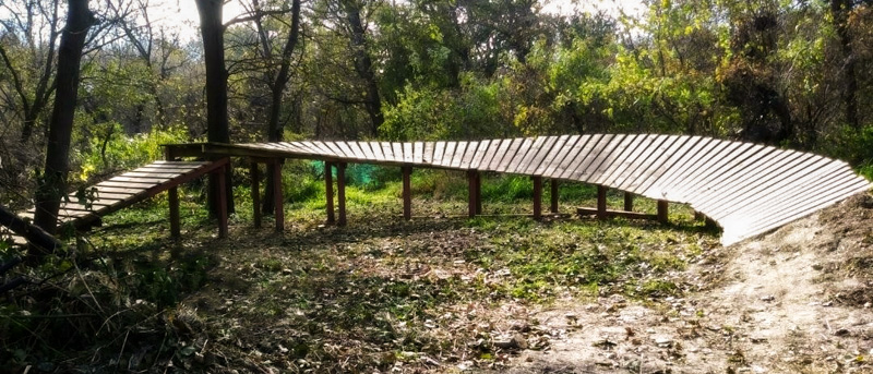
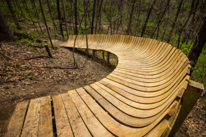
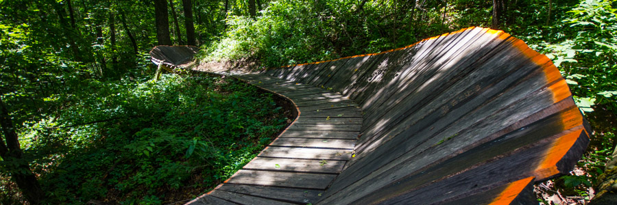
Wooden Berm at the Dog Park.
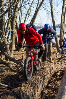
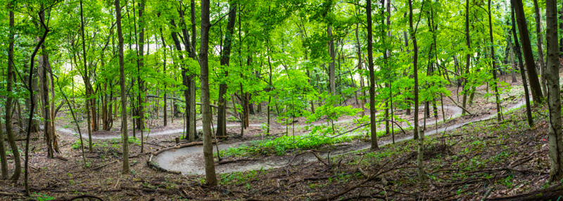
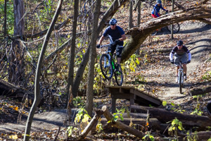
The Dog Park Trails are located in the 21-acre wooded areas off North Marquette Street in Davenport, adjacent to the popular dog park. Boasting just under 3 miles of singletrack, The Dog Park Trails are the perfect urban getaway for every skill level. Enjoy the easy flowing beginner level (green) trails, or get lost in the wilderness with the mid-level (blue) cross country trails. For those wanting to test their mettle, The Dog Park is best known for its heavily featured (and easily sessionable) advanced (black) trails. With a bridge spanning both sides of Robin Creek, wooden and dirt berms, and enough jumps to satisfy even the most seasoned rider, The Dog Park is a versatile trail system that has something for everyone. The park is located a mile north of the Duck Creek bike path making access by bike easy from most places in Davenport. On street parking is limited so we suggest riding to the park if possible.

Click to enlarge
 ) Circling the interior of the east side, Valkyrie skirts the edges of the woodland and runs along robin creek with a few optional surprise features along the way.) Crossing Robin Creek to the west side of the park with a bridge on one end and a creek crossing on the other. Camelot is a short run with a flowy, optional jump line.
 ) A windy, cross-country trail on the east side of the park with several fun features along the way.
) Get lost on the west side with this windy, cross-country trail featuring many short elevation changes.
) A windy, cross-country trail on the east side of the park with several fun features along the way.
) Get lost on the west side with this windy, cross-country trail featuring many short elevation changes.
 Read More
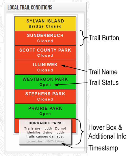
Trails are open to all permitted users.
Trails are closed to all users.
Trails are open but hazardous conditions exist. Hover over the trail button to see a popup description which may list more information about the specific hazard.
Trails are open IF they are FROZEN. This status is reserved for when trails experience freeze/thaw cycling and conditions are too variable to display accurately. See this article for more info about the freeze/thaw cycle and trails. Typically riding in the early morning before trails have a chance to thaw is the best option here. User discretion is advised. If you're leaving an imprint, the trails are too soft to be using.
If we aren't able to make contact with land managers who control trail closures to get a definitive answer on trail status this condition will be displayed so users may attempt to make contact themselves. Very rarely needed.
Other statuses may be displayed but will be self explanatory. See pop up message for details.

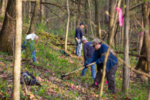
A short guide on how to prepare for a trail work day and tips to make the experience more enjoyable while keeping you safe.
Clearing & Grubbing - Clearing vegetation and debris from the planned trail corridor. Typically 4-6 feet in width. Stumps are removed that fall within the planned trail tread. Hand saws, chainsaws, & rogue hoes are best suited here.
Benching - Involves digging into the hillside to create a flat surface for the trail tread. This flat ledge is called a bench. Rogue hoes and flat shovels do a majority of this work.
Dirtwork - Creating berms, rollers, and other built up dirt features. Dirt is piled in the location of the feature, roughly shaped with a rake, compacted with a tamper, and the shape fine tuned using flat shovels.
Armoring - A trail hardening technique used in areas where severe erosion or mud is likely to occur. This involves placing ...
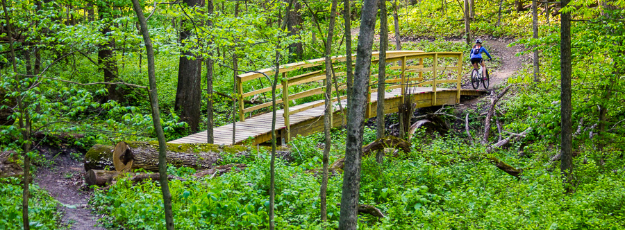
The green trail passes through a deep ravine with large Glulam bridge.
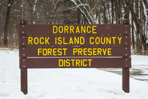
Dorrance Forest Preserve is located right in the middle of Port Byron, IL making it a prime choice for recreation and specifically trails. This 80 acre park features moderate to steep terrain and is covered by large hardwood trees typical of the Mississippi River valley. The park is located just a short ride from downtown Port Byron making it a convenient recreation destination for locals or those just visiting.
Click to enlarge
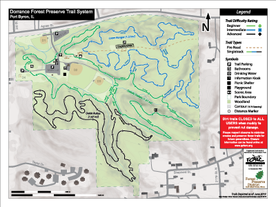
Three main loops of trail will be constructed at Dorrance. A green beginner loop, blue intermediate loop, and black advanced skills loop. Each trail will be around 1 mile in length with approx. 4 miles of trail in total when finished.
) A 1.6 mile loop tracing the interior of the park. A wider trail surface and low gradients makes this a good fit for beginner riders. The loop features a couple moderate climbs and one long descent. Enter/exit near the kiosk along the entrance road.) A 1.5 mile loop with numerous rollers, rock features, optional drops, and a few short climbs. One way only trail! (CW)
) This trail features, drops, steeps, steps, log overs, ladder bridges, and other advanced features to challenge riders (some without ride-arounds). Features will be added on Phase II during the winter/spring 2018/2019. One way only trail!FORC is working with RICFPD to develop new trails at Dorrance. The green/beginner loop was completed in spring 2017 and the intermediate skill level blue loop in Fall 2017. There is one more trail being ...
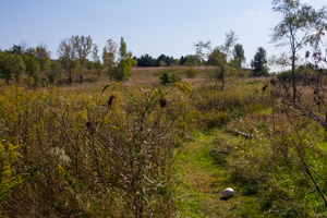
Looking over the prairie trail at Geneseo Prairie Park.
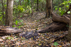
Geneseo Prairie Park (GPP) is located on the northern outskirts of Geneseo across from the Hennepin Canal Parkway Trail. There are ~55 acres of forested and restored prairie land at the park on which ~1 mile of old school doubletrack/singletrack hiking trail exists.
Most sections of trail are easily ridden on a mountain bike but there are a couple of punchy climbs that might require a dismount. We recommend avoiding the Ike's Fen trail (closest to the canal) because it has many muddy areas, slick narrow boardwalks (ie. 2x6's laid on the ground), and a RR tie stairway that requires a hike-a-bike.
Soils at the park are very sandy which lends itself well to fat bikes and quick dry times after rain.
Small log over on one of the trails at Geneseo Prairie Park.
Trail difficulty falls between beginner (green) and intermediate (blue) skill level. Expect a couple punchy climbs, some tight loose corners, and a few small trail features.
The existing trails are not well signed but trail maps are posted near common access points which are helpful. The trails are laid out in a network with many intersections in the forested area. It's possible to stitch together a large loop that will incorporate most of the trails.
Click here to view the trail map currently posted on the kiosk.
FORC maintains eight trail systems within the greater Quad Cities area containing over 42 miles of singletrack. Click the links below to see more information about each trail system such as trail maps, trail descriptions, directions, and hours.
Freeze thaw cycles refer to the thawing and refreezing process soils experience during colder months. Air temperatures hovering around freezing and variance in solar irradiance throughout the day are the driving factors for freeze/thaw cycling. Dirt trails are extremely prone to rut damage during the transition to/from winter because of this process. During freezing, soil particles are forced apart by expanding ice crystals which essentially de-compacts the trail bed. When these ice crystals melt with warming daytime temps these small spaces fill with water and form a very liquid like mud. Trails in this condition have almost no mechanical strength to support the weight of users. Water logged dirt the consistency of pudding or peanut butter is not uncommon during the spring thaw. It's very easy to make deep ruts when the dirt is in this condition since the frost de-compacting action can reach several inches in depth.
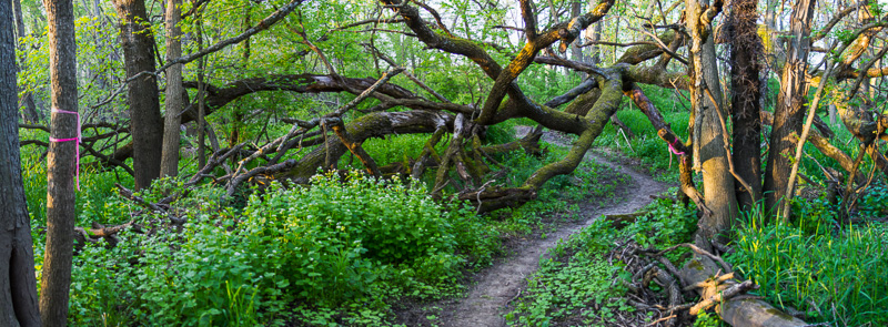
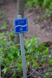
The 206 trail weaves through branches of a large fallen tree.
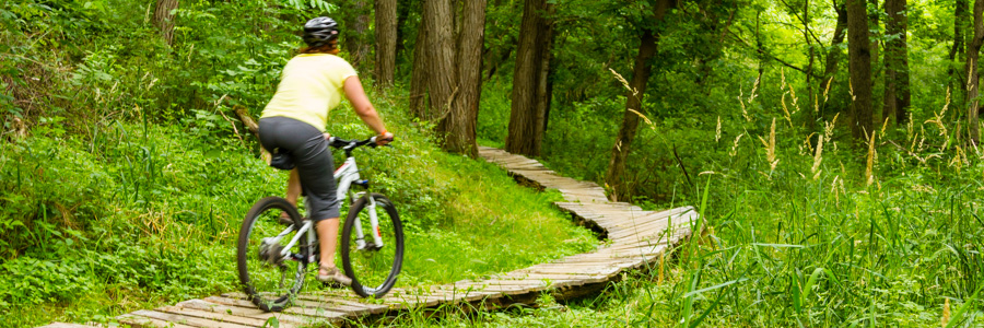
After nearly four years of hard work and over 1000 volunteer hours logged, eight loops of singletrack trail at Westbrook Park have been constructed. Riding all trails will result in a 6.3 mile lap. These trails were designed with sustainability and user experience in mind meaning lots of curves, gentle grades, good flow, and easy wayfinding. The system offers many trails that are beginner friendly with lesser technical challenge and minimal elevation change but more skilled riders can still appreciate a smattering of features on the blue trails.
Temporary signage has been installed marking each loop and its difficulty rating until more permanent signage can be put in place. Trail blazes engraved with the trail number and difficulty rating can be found along the loops and were manufactured/donated by Custom-Pak in DeWitt. See the trail map for suggested riding direction (counterclockwise).
The trails are marked frequently with blazes. Donated by Custom-Pak in DeWitt
101 - Beginner - 1.45 mi -
The 101 loop generally traverses the south and east perimeter of the park and is the main gateway to all other trail loops.. There is a short climb 0.3 mi after crossing the Silver Creek bridge (going in a CCW direction) but minimal elevation gain through the rest of the loop. There are plenty of areas routed through tight woodlands featuring gentle sweeping turns.
102 - Beginner - 0.71 mi -
The 102 loop begins by following the eastern boundary of the park before turning back along the the slopes of Silver Creek. Along the creek riders will encounter a short descent and climb, flowy turns, and gently rolling terrain.
201 - Intermediate - 0.64 mi -
The 201 loop snakes through the southwestern corner of the park and begins with a gentle climb to the top of a plateau. Once on top, the trail winds its way through open woodlands with minimal elevation change, transitions to a short turn packed descent, through a small ravine/stream crossing, and finishes along the banks of an undulating watershed.
202 - Intermediate - 0.57 mi -
The 202 loop starts as a short climb to the top of a small bluff that overlooks the lowlands surrounding Silver Creek. Next comes a short zig-zagging descent down a gentle watershead towards a small feeder creek and follows it upstream to the south. Moderate rolling terrain with sweeping corners eventually get you back to the top of the hill and reconnect with 101.
Stream crossing on the 206 trail.
203 - Intermediate - 0.51 mi -
203 hugs the east property line and features
...
Boardwalk on the Tarmac trail.
The Scott County Park trail system offers the largest amount of singletrack at one location in the QC area. A full loop will be near 11 miles in length. The trails offer a variety of difficulty level from beginner to advanced and explore the diverse terrain and natural areas of the park. Trail character varies from open and flowy to extremely tight and twisty (bring the 26er!) with some short climbs and descents thrown into the mix. Be sure to try the many, optional, technical features along the way to add an extra challenge.
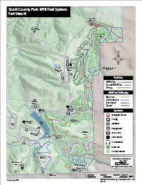
Click to enlarge.
3.0 mi) Meandering paths through deep woods, open prairie and pine forest. With a small creek crossing thrown in for fun. 1.76 mi) Open rolling wooded terrain, tall grass prairie segments, and "tunnels" through dense thicket. A 20 foot arched bridge takes you over Glynn's Creek. 1.46 mi) Intermediate trail with tight, sharp turns and a fast downhill. Small roots, several small jumps and log skinnys lead to a challenging climb out at the end. 0.95mi) A couple nice climbs, long boardwalks, and a rewarding switchbacking descent through a large meadow overlooking Pride Lake. 0.48mi) Twisty and flowy with a few moderate climbs. A section of log rollovers and skinny's keep it interesting. An optional small drop brings you back to the main trail. 0.18mi) Fun twists and turns lead to a steep 'pop-up' section that takes you out of the ravine. 1.84 mi) Short punchy climbs, narrow and twisty, and a few optional log ride features. This one will test both your bike handling skills and your lung capacity. 0.61 mi) Many short and extremely steep climbs/descents through a stream bed, wooden ladder bridges, and numerous slow speed technical features. Bring your A game and a set of grippy tires.In addition to the singletrack trail system, there are also 5-6 miles of mowed grassy doubletrack trail that follow the perimeter of the park. These trails are open to equestrians, hiking, biking, and cross country skiing in the winter. There are also a few miles of hiking only trails located in the interior of the park. Check out the park overview map for locations of these trails.
Overlooking a lower section of the North Loop descent.
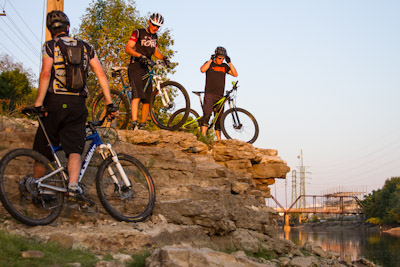
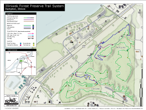
Set amongst the bluffs of northern Rock Island County, Illiniwek Forest Preserve features 5 miles of ultra flowy singletrack with the longest sustained climbs and descents in the QC area. The park offers a wide range of amenities besides the off road trails and is located on the Great River Trail bike path for easy car free access.
Wooden berm on the South Loop descent.
The trail system is made up of five miles of purpose built single track trail which will satisfy riders of all abilities. The trails follow the natural contours of the surrounding terrain with many overlooks of the Mississippi River Valley and the park's deep ravines. One large ravine divides the park separating the trails into two distinct systems: the North and South loops.
North Loop: Many ...
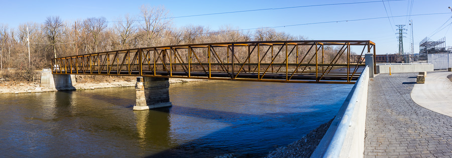
Sylvan Island's new bridge!
Sylvan Island is a wild place to ride.
Sylvan Island Park is a great urban trail system located in Moline, Illinois just 3/4 mile West of the John Deere Commons and the iWireless Center (formerly the Mark of the Quad Cities). The island was once home to a steel mill from which remnants can still be seen such as concrete loading docks and building foundations, railroad tracks, rebar, and loose rock. Despite few elevation changes, the unique nature of the island’s trails makes Sylvan Island Park a fun yet challenging and technical place to ride. The rocky soil composition at Sylvan Island allows for quick drying after precipitation often making it the first available trail system ...
Berm bridge on the Jubilee trail.
Sunderbruch Park is the crown jewel of off-road riding in Davenport, Iowa. Comprised of 99% singletrack trails, a full gamut of difficulty levels (green to black diamond) are incorporated into the seven mile trail system.
Sunderbruch's GREEN trails boast 2 miles of the most beautiful wooded scenery found in Davenport and test riders with a few small, beginner log crossings, one ladder bridge and one corduroy feature Our BLUE trails offer riders moderate changes in elevation, some rooted and off-camber terrain, a variety of corduroy sections and log-crossings, and large wooden berms and other wooden structures. BLACK Sunderbruch trails greet riders with fast descents and challenging climbs, creek crossings, some narrow winding trails, roots, skinnies, drops, and a plethora of logs. Sunderbruch has something to meet every rider's interest. You will not go home disappointed!
Typical feature on the Jump Line trail at Sunderbruch.
Trail List
) A short loop between the treeline and Blackhawk Creek near the parking lot. Geared towards younger riders with minimal climbing and easy to navigate trail. Enter/exit near the bike path bridge.) A quick climb from the parking lot to the top of the hill featuring a couple of boardwalks. Uphill use only!) A gentle rolling loop with a few roots and a fun downhill run towards the end.) A longer beginner friendly loop featuring more roots, a few small log skinnies, and a little more challenge.) Widely regarded as one of the most physically and technically challenging trails in the QC. Stream crossings, drops, high speed rooty downhill runs, and a couple leg burning climbs.) Fast and flowy section of trail with some climbing, drops, multiple bridges, and two large wooden berms.) High speed downhill run with some fun rollers and drops along the way and a moderate climb on the way out.
